


La Ciotat

Vox463
User
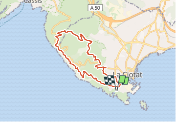

Length
16.1 km

Max alt
380 m

Uphill gradient
644 m
Km-Effort
25 km

Min alt
30 m

Downhill gradient
644 m
Boucle
Yes
Creation date :
2024-10-14 09:44:07.809
Updated on :
2024-10-14 09:44:36.116
5h36
Difficulty : Very difficult

FREE GPS app for hiking
 SityTrail
IGN / Geographical institutes
SityTrail Plus
The world is yours!
About
Trail Walking of 16.1 km to be discovered at Provence-Alpes-Côte d'Azur, Bouches-du-Rhône, La Ciotat. This trail is proposed by Vox463.
Positioning
Country:
France
Region :
Provence-Alpes-Côte d'Azur
Department/Province :
Bouches-du-Rhône
Municipality :
La Ciotat
Location:
Unknown
Start:(Dec)
Start:(UTM)
711258 ; 4782684 (31T) N.
Comments